
4M Analytics
4M Analytics is an AI-powered Utility Mapping Platform that consolidates fragmented public utility records and satellite imagery into a single, reliable map verified by geospatial experts, enabling infrastructure owners, planners, designers, and builders to instantly access accurate utility data throughout planning, design, and pre-construction phases to identify risks early, reduce field time, and keep projects on schedule and within budget.
Close
What is it you are searching for ?
Search our site for products, services, training and support

Connect with providers of complementary solutions to drive successful infrastructure projects
Explore and engage with our global, innovative ecosystem to streamline workflows, and achieve greater efficiency.
Slide 1 of 1
Search 4M Analytics
4M Analytics
4M Analytics Inc.
Enquire Now
Solution Type:
Applications and Plug-ins
Platform Category:
- Bentley Infrastructure Cloud
- iTwin Platform
- Open Applications and MicroStation
Lifecycle Phase:
- Build
- Design
- Operate and Maintain
Industry:
- Energy Production
- Transportation
- Water Utilities
Web Page:
4M | The Google Maps of the subsurface
Solution Description
Instant, reliable utility data. Powered by AI. Verified by humans.
4M is the first Utility AI Mapping Platform built for infrastructure owners, planners, designers, and builders. Powered by proprietary AI and verified by geospatial experts, 4M compiles millions of fragmented public utility records and satellite imagery into one easy-to-use map—giving teams instant access to utility data they can trust and verify at every stage of planning, design, and pre-construction.
Trusted by CDOT, TXDOT, GDOT, HDR, MasTec, and Kimley-Horn, 4M replaces manual research and scattered records with a single source of truth—helping teams identify risks earlier, reduce field time, and keep projects on time and on budget.
Benefits
Instant Access to Utility Data
Get verified utility data in seconds. Eliminate 90% of manual research time and move faster from scoping to design.
Comprehensive, Reliable Coverage
Access consistent utility data—regardless of project size or location. 4M compiles utility records, generates missing lines using AI, and validates with detected surface features and expert QA.
Smarter Estimates, Tighter Budgets for Infrastructure Projects
Start with complete utility visibility. Reduce contingency padding, avoid hidden costs, and save up to 85% on utility investigations—plus tens of thousands in indirect costs tied to redesigns, delays, and claims.
Early Utility Conflict Detection
Flag utility conflicts and ROW impacts before design begins—cutting up to 50% of unnecessary field work and minimizing downstream risk.
Features
Access a complete utility baseline map—instantly. 4M compiles millions of public records, permits, GIS sources, and satellite imagery into a single map with utility lines, ownership details, attributes, and source references.
Where records are missing or incomplete, 4M uses AI to infer utility paths based on adjacent data, utility objects, parcel logic, land use patterns, and source imagery.
Detects manholes, valves, hydrants, poles, meters, and other surface indicators with 95% accuracy, enabling teams to visually confirm utility presence and guide field investigations.
Utility Insights & Risk Analysis
Analyze potential conflicts, relocation impacts, and ROW constraints with an interactive dashboard linked to the map—flagging high-risk crossings, critical parcels, and utility density zones in real project context.
Validated Utility Data
Get expert-reviewed utility maps with corrected linework, repositioned geometry, and QA applied using imagery, engineering documents, geospatial mapping techniques, and supporting evidence—delivered with higher confidence for use in design, permitting, and PS&E.
View time-stamped paint markings, flags, and posts captured from street view and satellite imagery for supporting evidence to confirm utility line presence and location.
Enterprise Controls
Manage access, roles, usage, and data governance across teams and regions with project-level permissions and admin dashboards.
Transportation Planning
Evaluate multiple road alignment options with utility ownership details, potential conflict matrix, parcel and ROW overlays, and utility density maps—helping planners and coordinators avoid high-risk areas, minimize relocations, and align earlier with utility owners before design progresses.
Utility Routing
Compare and evaluate multiple relocation routes with route comparison and crossing analysis tools to identify high-risk crossings, refine relocation plans, and deliver PS&E-ready designs earlier.
4M Agents
Built on our Geospatial Agentic Framework, 4M Agents use LLMs to deliver early risk assessment, utility impact analysis, and coordination workflows. The first 4M Agent focuses on SUE Service Planning—pinpointing where different quality levels are needed, estimating SUE costs, and prioritizing locations based on complexity, safety, and project impact.
Export to GIS & CAD
Export utility data into SHP, DWG, DXF, DGN, KML, and other formats directly into GIS, CAD, and BIM environments.
API Integrations
Connect 4M directly into ArcGIS, Bentley, AutoCAD, Trimble and Esri. Use API access to automate utility data delivery, support real-time validation, and keep GIS, CAD, and permitting systems in sync.
Bentley Brands Associated with Solution
- iTwin Experience
- Map
- MicroStation
- OpenRail
- OpenRoads
- OpenSite
- OpenUtilities
Images


Video
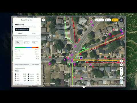
Minnesota Foundation Data Launch
4M is the first Utility AI Mapping Platform built for infrastructure teams. It delivers instant, reliable utility data you can trust and verify—at every stage of planning, design, and pre-construction. Our centralized mapping solution compiles millions of scattered public utility records into one easy-to-use map, saving you time and money on conventional record research, extensive field investigations, and costly surprises. Think of it as a comprehensive utility repository: One platform for all utilities. Powered by AI. Verified by humans.
Learn more here: https://www.4manalytics.com/

4M Analytics: Evolving Infrastructure with Utility AI Mapping
Learn more at https://www.4manalytics.com/