
Skyportal™: AI-Powered 3D Modeling & Digital Twin Platform by Skyfish
Skyportal™ by Skyfish LLC is a cloud-based AI-powered platform that converts drone-collected imagery into precise 3D models and digital twins for critical infrastructure inspection, offering advanced analytics and seamless CAD/GIS integration to support industries such as energy, government, mining, and transportation in operating and maintaining infrastructure with high accuracy and regulatory compliance.
Close
What is it you are searching for ?
Search our site for products, services, training and support

Connect with providers of complementary solutions to drive successful infrastructure projects
Explore and engage with our global, innovative ecosystem to streamline workflows, and achieve greater efficiency.
Slide 1 of 1
Search AI-Powered 3D Modeling & Digital Twin Platform – Skyportal™
AI-Powered 3D Modeling & Digital Twin Platform – Skyportal™
Skyfish LLC
Enquire Now
Solution Type:
Data and Data Capture
Data Solution Type:
Data Set
Platform Category:
- iTwin Platform
Lifecycle Phase:
- Operate and Maintain
Industry:
- Energy Production
- Government
- Mining
- Transportation
Web Page:
https://skyfish.ai/solutions/osprey-drone/
Company Description
Skyfish is a trusted provider of precision drones and software for critical infrastructure inspection applications. Skyfish is committed to driving innovation and delivering measurable outcomes. Our team brings deep expertise in high-accuracy measurement, regulatory compliance, and integrating hardware and data pipelines to deliver AI-powered 3D reality models ("digital twins") that enterprises and agencies can rely on to achieve global impact at scale.
Transform infrastructure inspection with precision digital twins, advanced analytics, and seamless CAD/GIS integration
Solution Description
Skyportal™ is Skyfish’s cloud-based rendering, visualization, and AI engine that transforms drone-collected imagery into precise 3D models and digital twins. Optimized for infrastructure inspection, Skyportal™ enables users to measure sub-centimeter details, detect and classify assets with AI, and manage photo, video, and model data in a secure, browser-based platform.
Engineers and operators can collaborate through a centralized dashboard, explore infrastructure in a powerful 3D viewer, and export models into CAD, GIS, and engineering software (e.g., Esri, SolidWorks, Risa-3D). With support for precise geotagging, automated rendering, and advanced analytics, Skyportal™ delivers the accuracy, interoperability, and scalability required for mission-critical infrastructure projects—all developed and manufactured in the USA and NDAA compliant.
Class
Database
Resource Type
- 3D Model/Mesh
- Image: Ortho
Benefits
Better photos make better models
Skyfish's Osprey drone is specifically designed for photogrammetry and is tightly integrated with the SONY ILX-LR1 61-MP camera, and our data processing engine Skyportal, to deliver the best 3D models / digital twins available on the market.
We guarantee accurate meta-data is collected and injected into every image. Geotagging is based on a proprietary Skyfish sub system that offers a 30hz frame synchronous injection circuit. As part of the process, our flight software dynamically generates an optimized flight path so the drone can capture the right image, in the right location, with the right pose.
Using Al to understand infrastructure
Skyportal™ uses machine learning to auto-detect and identify elements of infrastructure in the 3D model.
Post flight, the captured data is uploaded to Skyportal, our rendering, viewing, and Al engine. Rendering can be automatically initiated, resulting in complete models within hours of collection.
Using sophisticated algorithms, Skyfish extracts the exact, minute, detailed features from thousands of photos, correlates and triangulates these features, then warps and stitches the photos seamlessly into a life- like replication (digital twin) of target infrastructure.
The 3D model is so detailed you can measure the thickness of steel, measure a cotter pin in a bolt, or the length of a cable to sub- centimeter accuracy inside the model. Using our Osprey drone and the LR1 camera will result in the most accurate models but our solution can ingest photos from any platform to render your models.
Made in the USA & NDAA compliant
Skyfish's drone hardware and software are developed and manufactured in beautiful Missoula, Montana. Skyfish is NDAA compliant, certified Airworthiness Level 3 by U.S. Army DevCom, and is Green UAS in process.
Features
Dashboard
The Skyportal™ dashboard is a centralized view of available models, updates, activity, media, and more. Users can search and filter their list, select a model or start creating a new model. Models can also be archived or deleted.
Model Details
The Model Details section provides information about the model such as the location on a map, the model type, the physical site, geographic coordinates and processing time. Users can see the various renders along with their time frames, and compare renders. For instance, users can enter the height of a tower, the area of the compound, or how many rad centers are on the tower. Details related to the mission can also be added such as dates, the operator's name, or a site manager's name.
3D Viewer
Next, users may wish to open the 3D viewer to see their infrastructures' digital twin. This is where the user can do things like measure the thickness of steel with the built-in ruler, review the automatically generated mount-maps and export them. They can make annotations, look for missing/damaged hardware, or use the in-model photo viewer to look at specific images.
Photo Gallery
In the Photo Gallery, users can view, manage, download, and share photos and videos of their infrastructure. They can also select, bookmark, share points of interest, dive deeper for further analysis, create annotations on any photo, generate annotation reports, and download any photos required.
Reconstruction
Reconstruction involves going into a defined region of interest and begin processing. The processing engine runs and will notify the user once complete. Users can then review the results and retry or accept. Lastly, post processing runs to automatically detect certain types of equipment on the tower.
Add a New Render to the Model
Select the image set to process and then the upload begins in the Skyportal™ servers. Within that uploader, there are a couple of useful components such as checking for any incorrect meta data. Users are provided a map showing the positions of the photos to better understand the flight path and where in 3D space the images are. This is also helpful for verifying various aspects of the mission. After the upload is completed, a guided process occurs, and aero triangulation begins to process. Once complete, the user will be notified and can then review the process, accept results, or try again.
Web-Based and Team Shareable
Skyportal™ is web-based and can be accessed from any browser from any location. To support user ease, especially in the field, there is nothing to install. Scale as needed to support bigger vs smaller projects and teams. Skyfish utilizes OAuth as a standard security and sharing protocol for sharing information between the Skyfish system and a customer's system.
Security
Skyportal™ is AWS-based and customer data is secure and encrypted.
Export Types
Skyportal™ also enables export to CAD, Esri, Excel, OBJ, LAS, Geo Tiff, orthomosaics and more for further data analysis allowing engineers to work easily between tools. Export a 3D model as a DXF, open in Risa- 3D or SolidWorks. Add and assign material properties, rigid links, loads, contacts, boundary conditions, obtain critical stresses and displacements.
Standard Feature Set
Distance and height measurements, annotations, region of interest, map of models, grid view of models.
Premium Feature Set
Advanced Analytics: Precise measurements, object recognition, classification, report compilation, and export. Skyportal™ provides detailed insights on your infrastructure inventory. Obtain critical displacement data and stressors.
Bentley Brands Associated with Solution
- iTwin
Coordinate Reference System
WGS84
Data Format
3D Mesh, Orthomosaic, and LAS Point Cloud
Data Source
IoT Sensors
Update Frequency
On-demand
Integration Options
- Bentley iTwin
Type of Access
Subscription Based
Data Size & Storage
As little as 1 MB, as much as 200+ GB
Security and Compliance
- ISO 27001
Additional Material
Skyfish Osprey Drone Platform - Solution Sheet
Skyportal - Solution Sheet
Skyfish 3D Modeling Capabilities - downloadable brochure.
Images


Video
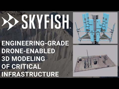
Skyportal - Skyfish Customer Data Portal for Precision 3D Modeling, Analytics, and Reporting
Skyfish provides a fully integrated drone and data platform. Its RTK-enabled Osprey drone geotags every photo in 3D space to generate engineering-grade datasets, which render into world-class digital twins in Skyportal™.
Skyportal™ is Skyfish’s cloud-based rendering, visualization, and AI engine that converts drone-collected imagery into precision 3D models and digital twins. Built for infrastructure inspection, it lets users measure sub-centimeter details, detect and classify assets with AI, and manage data in a secure browser-based platform. Engineers can collaborate via a centralized dashboard, explore assets in a powerful 3D viewer, and export models into CAD, GIS, and engineering software (e.g., Esri, SolidWorks, Risa-3D). With precise geotagging, automated rendering, and advanced analytics, Skyportal™ delivers the accuracy, interoperability, and scalability required for mission-critical projects. Skyfish drones and Skyportal are developed in the USA, NDAA compliant, and on track for Blue List and Green List approval.