
MappAir® Global Air Quality Modelling Suite
MappAir® Global Air Quality Modelling Suite by EarthSense Systems Ltd is a high-resolution, cloud-based air pollution model that integrates transport, weather data, and machine learning to provide compliant, near real-time, historic, and predictive air quality visualizations and insights across multiple sectors including energy, government, mining, and transportation.
Close
What is it you are searching for ?
Search our site for products, services, training and support

Connect with providers of complementary solutions to drive successful infrastructure projects
Explore and engage with our global, innovative ecosystem to streamline workflows, and achieve greater efficiency.
Slide 1 of 1
Search MappAir® Global Air Quality Modelling Suite
MappAir® Global Air Quality Modelling Suite
EarthSense Systems Ltd
Enquire Now
Solution Type:
Data and Data Capture
Platform Category:
- Open Applications and MicroStation
Lifecycle Phase:
- Operate and Maintain
Industry:
- Energy Production
- Government
- Mining
- Transportation
Web Page:
https://www.earthsense.co.uk/mappair
Past, present & predictive air quality data for a host of sectors
Solution Description
MappAir® is a high-resolution global model of air pollution that uses advanced modelling techniques, cloud-based data inputs including transport and weather data and applies machine learning technologies to create reliable and usable visualisations of air pollution around the world.
It allows users to understand key emission sources within an area of interest, complete with near real-time, historic and predicative air quality data for detailed and actionable insight into pollution trends.
MappAir's data accuracy is within and compliant with the limits outlined within The Air Quality Directive (2008/50/EC) guidelines.
Class
Dataservice
Resource Type
- Image: Satellite
- Map
- Sensor
Benefits
Use of MappAir
Features
Global Air Quality Modelling Suite
Bentley Brands Associated with Solution
- iTwin Experience
Creation Date
2025-10-03T00:00:00
Data Format
CSV, API, Web portal
Data Source
Emissions Inventories (cars,motorbikes,LGV,HGV), Shipping (Ports,Rail), RWC, Satellite Imagery
Update Frequency
On-demand
Integration Options
- Bentley iTwin
- Other (Specify)
- REST API
Other Integration Option
Modelled Data as well as Annual Averaged Data Sets
Type of Access
Subscription Based
Security and Compliance
- GDPR Compliant
- ISO 27001
Sustainability Impact Overview
Visualising and modelling air quality emissions to help identify and implement reduction of emissions and to improve climate resilience.
Sustainability Challenge - Climate Action
- Climate change mitigation/decarbonization: sustainable construction practices
- Green infrastructure
Sustainability Challenge - Healthy Cities and Communities
- Air quality, Noise reduction
- Holistic management of city areas, Smart, digital cities
- Promotion of health and well-being
Sustainable Development Goals (SDGs)
- SDG 11 – Sustainable Cities and Communities
- SDG 13 – Climate Action
- SDG 15 – Life on Land
- SDG 3 – Good Health and Well-being
SDGs Justification
SDG # 3 / Justification: Supports good health and well-being by helping to identify pollution movements to make informed decisions. SDG # 11 / Justification: Helps contribute toward good sustainable city designs with pollution data sets. SDG # 13 / Justification: Supports informed decisions on supporting taking action in environment. SDG # 15 / Justification: The modelled data sets help to inform on pollution events and promote a healthy lifestyle on land.
Video
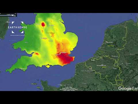
MappAir® - Evolving NO2 concentrations for the UK 10.01.19
Hourly nitrogen dioxide concentrations for the whole of the UK on 10.01.19 - mapped with MappAir® by EarthSense.
a6467108339449856.cdn.optimizely.com
a6467108339449856.cdn.optimizely.com is blocked
This page has been blocked by an extension
- Try disabling your extensions.
ERR_BLOCKED_BY_CLIENT
Reload
This page has been blocked by an extension