
TerraPhoto
TerraPhoto by Terrasolid Ltd. is an advanced software application integrated with MicroStation that processes airborne and mobile LiDAR data to transform aerial imagery into precise orthophotos, colorized LiDAR point clouds, and textured 3D city models, supporting infrastructure projects across industries like energy, government, mining, transportation, and water utilities throughout design, build, and maintenance phases.
Close
What is it you are searching for ?
Search our site for products, services, training and support

Connect with providers of complementary solutions to drive successful infrastructure projects
Explore and engage with our global, innovative ecosystem to streamline workflows, and achieve greater efficiency.
Slide 1 of 1
Search TerraPhoto
TerraPhoto
Terrasolid Ltd.
Enquire Now
Solution Type:
Applications and Plug-ins
Platform Category:
- Open Applications and MicroStation
Lifecycle Phase:
- Build
- Design
- Operate and Maintain
Industry:
- Energy Production
- Government
- Mining
- Transportation
- Water Utilities
Web Page:
https://terrasolid.com/products/terraphoto/
Partner Spotlight:
https://www.bentley.com/partner-spotlight-terrasolid/
Company Description
Terrasolid provides advanced software for processing airborne and mobile LiDAR data We help professionals turn 3D point clouds into actionable insights for mapping, modeling, and analysis
Transforming Aerial Imagery into orthophotos, colorized LiDAR point clouds or schematic textured 3D City models
Solution Description
By seamlessly integrating laser scan information from survey missions with state-of-the-art image processing, TerraPhoto delivers rectified images and high-quality ortho mosaics with exceptional precision. Leveraging accurate ground models derived from LiDAR data, TerraPhoto provides professionals with clear, reliable visuals for effective planning and decision-making.
Its ability to create true-ortho photos using vector models and selection shapes for specific areas is complemented by its capability to generate 3D building textures by rectifying images on facades and roofs. By converting complex survey missions into intuitive, actionable visual data, TerraPhoto stands out as an indispensable tool for anyone involved in geospatial imaging, digital twin creation, or 3D city modeling.
Typical use cases for TerraPhoto span across various industries: • Urban Planning and 3D City Modeling: Ideal for government agencies and city planners, it allows for the creation of detailed digital twins and accurate, visually rich urban models. • Infrastructure Management: Precise, rectified images help monitor and manage critical infrastructure, ensuring efficient maintenance and informed upgrades. • Geospatial Analysis: Professionals in mapping, surveying, and environmental monitoring can rely on TerraPhoto to transform raw data into actionable, high-quality visual and spatial information.
Benefits
Intelligent tie points and robust ground control points ensure precise image alignment and superior positional quality.
Streamlined Aerial Image Processing
TerraPhoto automates the conversion of raw aerial imagery into georeferenced, corrected outputs like True Orthophotos, 3D building model textures and colorized point clouds.
Advanced correction and enhancement algorithms deliver precise, high-fidelity imagery that greatly improves data interpretation.
The application seamlessly interfaces with other tools in the Terra suite, creating a unified workflow for diverse geospatial projects.
Automation and batch processing reduce both project turnaround times and operational costs, making it ideal for large-scale deployments.
Features
Processes aerial images to create orthophotos, mosaics, and georeferenced outputs with minimal manual intervention.
Advanced Correction Capabilities
Incorporates robust methods to correct lens distortions, perspective shifts, and radiometric inconsistencies for consistent image quality.
Accepts a wide range of input and output formats, ensuring compatibility with industry standard formats and different airborne and mobile camera systems.
Seamless Ecosystem Integration
Designed to work harmoniously with other Terrasolid applications, it supports a comprehensive, end-to-end geospatial workflow.
Support & Maintenance
Terrasolid YouTube Channel
TerraPhoto User Guide
Bentley Brands Associated with Solution
- iTwin
- MicroStation
- OpenCities
- OpenRoads
Images

3D City model textures created and rendered with TerraPhoto. TerraPhoto enables also video rendering using predefined fly path and camera settings.

Point cloud coloring on the fly dynamically based on raw images attached in TerraPhoto.
Video
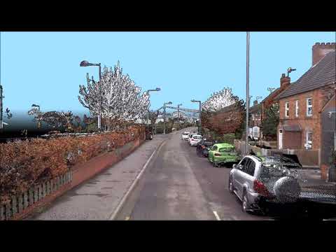
TerraPhoto fly thru video of mobile point cloud data
The point cloud has been processed using TerraMatch and TerraScan. Colorized with TerraPhoto using images from Ladybug 5 -camera. The data has been collected by GeoSLAM.
The used camera path was 900 meters and 4500 images were rendered for the video using 60 degrees camera angle.
#LiDAR #RoadSurvey #MobileMapping

Colorizing Airborne data from Orthomosaic using TerraScan and TerraPhoto
Simple way to colorize the pointcloud by using attached Orthomosaic. Extract color from images command extracts color values from raster images and assigns the values to laser points. The color sources can be orthophotos attached as TerraPhoto raster references or raw images in an active TerraPhoto image list.
#LiDAR #PointCloud #PointCloudIntelligence
Working with 3DCityDB using TerraScan and TerraPhoto
Video content: - Connecting TerraScan to PostgreSQL/PostGIS/3DCityDB - Writing buildings vectorized by TerraScan and texturized by TerraPhoto into 3DCityDB - Reading buildings with textures from the database for editing - Editing building geometry with TerraScan using Hi-res (Image color) point cloud display mode - Creating new textures for the edited building with TerraPhoto - Updating the database with the edited building - Reading edited building from the database for visual check - Rendering 3D buildings, colorized high vegetation points and DTM draped with the orthophoto
Data courtesy of City of Kerava
#3DCityDB #3DCity #LiDAR